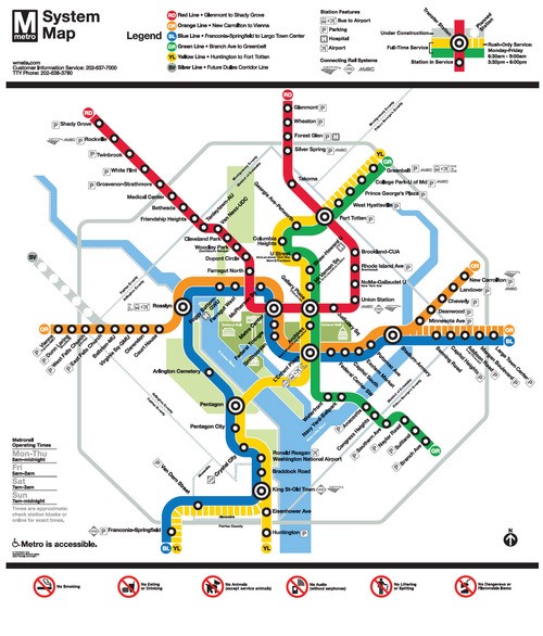
Metro is rethinking signage for its subway system, as GreaterGreaterWashington recently reported. The current design, which uses the end station name to signal train direction, may be supplemented or replaced by the cardinal direction in which a train is heading. While it is an improvement, Metro should do more to improve wayfinding. As a start, Metro should:
- Assign numbers for all the stations on a particular line in numerical order in addition to using the names of station
- Identify a point of interest along the line to help orient passengers on the direction a train is heading, in addition to identifying the end station on a line
- Indicate whether the train is heading towards or away from DC (inbound/outbound), and for trains inside the city center, indicate the cardinal direction the train is heading.
Getting from A to B
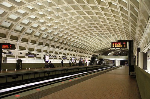
These recommendations are made on the basis of how people conceptualize navigating. Generally speaking, humans use three techniques to navigate from point A to point B. First, some people have an inherent sense of direction and easily can distinguish north, south, east, and west. They merely need to be told to travel in a particular direction and the distance. Second, some people use landmarks to navigate. For example: travel down the street and once you see the gas station on your left, make a right turn and go until you see the library. Third, some people follow step-by-step directions. Go four blocks, make a left on L St., go another two blocks, your destination is on the right. Most people use a combination of these techniques. None of these techniques works particularly well in Metro. The stations are largely underground and indistinguishable from one another. A fair number of riders are out-of-town visitors who have not had time to build a mental map. Metro’s use of the final station on a line to indicate direction is confusing to many people, including long-time residents. Other considerations may arise for the visually impaired. And, of course, Metro’s cryptic signage system largely is unhelpful.
Best practices
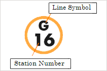
Other transit systems use various techniques to facilitate wayfinding. One technique is to have transit stations on a line numbered in addition to having a name. For non-English-speaking visitors, this can be invaluable. Arabic numerals are widely used throughout the world and are easily understood. For out-of-town visitors, numbering stations allows passengers to anticipate how many stops until this time to exit the train. Additionally, increasing or decreasing numbers can be an easy clue as to the direction of train is traveling. This is used in Tokyo.
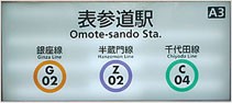
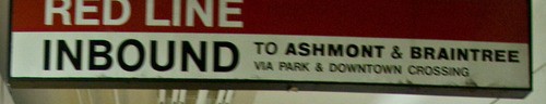
Another technique is to contextualize the direction of train is traveling. For example, New York City identifies trains are traveling downtown or uptown. Boston trains often indicate “ inbound” or “outbound.” London’s tube indicates cardinal direction). In other places, station signage will make it clear what the next station is in the line of travel. Or, perhaps more helpfully, indicate a significant point of interest in each direction.
Transit systems in other countries use a number of other techniques. Standard verbal announcements on trains and maps on trains that indicate the current location and the direction of travel are comparatively poorly implemented in DC’s Metro system. Similarly, Metro station signage is sparse, cryptic, and unhelpful. Often times, directions are not available at the points where passengers must make decisions. My favorite contextual clue is the musicplayed by each subway line in Tokyo.
By taking account of the different ways that people navigate and best practices from other transit systems, Metro could make itself more welcoming and reduce the number of passengers who are lost, confused, and underfoot.
Originally published at www.danielschuman.com.
— Written by Daniel Schuman